

If you love to take to the back roads of adventure, we rank these iconic trails in order of difficulty:
Mohave Wash- Easy for Jeep, SUV, ATV, and dirt bikes
Description: A remote desert drive for beginners or those looking for an easy day off-road. Read and follow all regulations posted on the information kiosk at the start of the trail. Soft sand, minor hill climbs and some rocky places. Use caution around mines. Some have exposed vertical shafts hundreds of feet deep. Don’t let children stray.
Details: About 34 miles for the entire loop. Allow 3 to 4 hours.
How to get there: Head south from Lake Havasu City on Hwy 95. Turn left into Standard Wash 0.6 miles past mile marker 173. Go past the brown BLM kiosk for Standard Wash before you turn left.
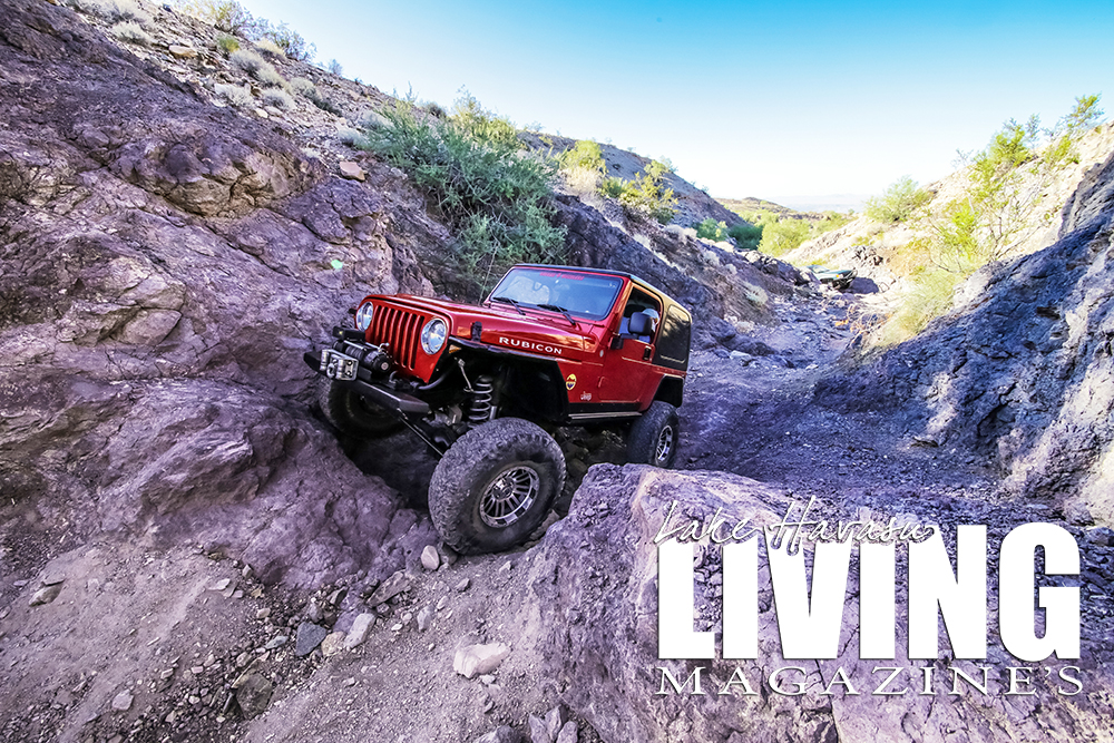
Swansea Townsite- Easy for Jeep, SUV, ATV, and dirt bikes
Description: This drive starts at the Bill Williams River National Wildlife Refuge where you can find over 275 species of birds. Also, squeeze through a dramatic Slot Canyon, before finishing at the Swansea Townsite, once a booming copper mining town. Swansea Townsite is larger than it first appears, and has designated trails for 4-wheel drive vehicles, ATVs, and dirt bikes. Mostly sandy wash bottoms and gravel roads except for a 3-mile stretch through the Bill Williams River National Wildlife Refuge. This section has short sandy climbs and several water crossings. The Slot Canyon is narrow, but easily passable. The trail is suitable for stock SUVs with moderate ground clearance. Route-finding is fairly easy. Flash flooding is possible in the wash bottoms and especially through Slot Canyon. Don’t enter if heavy rains are forecast. Always carry plenty of water.
Details: Time & Distance: More than 55 miles. Allow 4 to 5 hours plus extra time to explore Swansea.
How to get there: Head south about 19 miles on Hwy 95 from Lake Havasu City. Turn left onto a wide gravel road (Bill Williams Highway) just after the Bill Williams Bridge near mile marker 162. From Parker, turn right about a half mile past the Central Arizona Project Pumping Station.
Buckskin Mountains- Moderate for Jeep, ATV, and dirt bikes
Description: Moderately challenging, this backroad trip culminates at the Nellie E. Saloon, or Desert Bar. Stock vehicles will find this trail quite challenging. Several rocky sections require careful tire placement and the help of a good spotter. Other parts of the trail are soft and susceptible to water erosion. Conditions will worsen over time. Don’t drive the road under wet conditions. Route-finding is confusing at the start but gets easier as you proceed. Do not drive this trail by yourself.
Details: 5.5 miles to the bar going in the back way. This part takes about 1 to 2 hours. The exit route is 4.8 miles and takes about 30 minutes.
How to get there: On Hwy 95, head north from Parker or south from Lake Havasu City to River Island Market and gas station located between mile markers 155 and 156 on the south side of the road. The start of the trail is just west of a fenced-in RV storage area next to the market.
Crossman Peak- Moderate for Jeep, ATV, and dirt bikes
Description: The route crosses remote desert around the south and east sides of Crossman Peak, but does not go to the top of the peak. Drivers should be self-reliant and prepared for emergencies. Most of this trail is easy, but there is one hilly section that is fairly challenging. A couple rocky sections require careful tire placement. High ground clearance and skid plates are required. Route-finding is complex and confusing at times.
Details: Time & Distance: This long trip covers 36 miles off-pavement. Allow 4 to 5 hours.
How to get there: Head south from Lake Havasu City on Hwy 95. Turn left into Standard Wash 0.6 miles past mile marker 173. Make sure you go past the kiosk for Standard Wash before you turn left. Always stay on existing trails. Standard Wash is very wide and has several entry points but all eventually funnel together.
Cattail Cove- Moderate for Jeep, ATV, and dirt bikes
Description: Visit the rock formation, Rovey’s Needle, and stop for lunch at Cattail Cove next to the Bill Williams River. Mainly follows sandy wash bottoms with intermittent rocky sections. There are several difficult rock obstacles if you are looking for more challenge, but the worst places have bypasses. Route-finding can be confusing at times.
Details: 8.8 miles to Cattail Cove counting the side trip to Rovey’s Needle and 8.2 miles back out. Allow about 4 hours.
How to get there: Turn east off Hwy 95 just north of mile marker 165. The area looks like a gravel pit under major power lines. Located adjacent to Cattail Cove State Park which is on the opposite side of Hwy 95.
President’s Choice- Difficult for Jeep, ATV, and dirt bikes
Description: This trail is a real test of the best modified equipment. A lot of tall, jagged rocks with very little room to maneuver. Without a good spotter, expect body damage. Route-finding is confusing at the start.
Details: Very short. The hardcore part is only about a mile and can be completed in about an hour. Allow 2 to 4 hours, especially if you have a large group.
How to get there: Turn east off Hwy 95 on an unmarked wide gravel road between mile markers 149 and 150. Bear right where the road forks at 0.6 miles, then immediately turn right again off the gravel road into a broad area at 0.7 miles. Roads fan out in many directions.